After leaving Sajama I took two four hour buses to reach Oruro, one of the largest towns up on the Bolivian altiplano. This city is rather ugly and if an overnight bus was headed to my destination of Tupiza I would have taken it. But there was not. So I overnighted and woke early to book the afternoon train.
This train, that still trvels the track built 80 years ago from La Paz to Salta, now only runs from Oruro to the Bolivian/Argentinian border. It was the slowest, most bumpy train I have ever travelled on. Dinner was included, my first ever on a train. Felt like the Orient Express (Not!).
The train arrived in Tupiza at a cold 4.00am. So I knocked up the nearest hostel for a few more hours sleep. Then I booked a half day jeep tour to view the red rocks of Tupiza.
The following day I took the afternoon bus down to the town of Villazon, and crossed the border bridge to the small Argentinian town of La Quiaca. I decided to sleep here and get the Salta bound bus in the morning.
So here I am back once again in Salta. Here too the weather has turned bitterly cold. Last night snow was visible on the nearby Andean foothills. My full circle of the altiplano, and it's unique landscape is now done. Time now to turn away from the Andes and head east to the border of Argentina and Brazil (where hopefully it's a bit warmer).
Overnight bus tonight (29/05/07) to Corrientes on the Paraña river, just below Paraguay.
Tuesday, 29 May 2007
Friday, 25 May 2007
First shower in 4 days!!
Having spent the last four days wandering the highlands, in places without electricity, it was great to discover Sajama had a thermal pools. So up early armed with my towel I walked an hour an a half over to where the warm waters bubble up. It was lovely soaking away under this small waterfall, but getting changed after in the frigid air with a strong wind blowing was an anatomy shrinking experience.
It was wonderful wandering the Rio Sajama valley, with just llamas and alpachas for company. All around I was surrounded by snow covered volcanic peaks, including the other side of Parinacoto and Pomerape.
After my shower I walked back to the village to pack up and hopefully get a lift to the main road so I could catch a bus to move south to Oruro, the main town of the Bolivian altiplano.
I was successful.
Sajama was so remote, so beautiful. At night the wind clattered the corrugated iron roof of the room where I slept (under circa 5 thick blankets to counter the cold).
Trucking into Bolivia
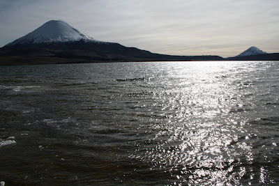
The next morning we drove around to Lago Chungara, right up against the Bolivian border. Here the volcanoes Parinacota and Sajama (in Bolivia) loom over the lake.
Then down to Parinacota village, where I lucky to see the Andean Ibis.
After a mid morning cuppa, it was over to the border for me, and here I said my goodbyes to William. The buses over the border were delayed, so it was arranged that a Bolivian truck driver would take me over the border to the road junction to Sajama, where I wanted to spend the night.
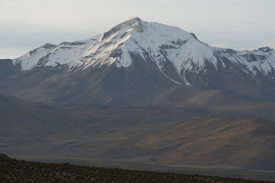
I luckily got my second lift of the day, taking me the 11 miles into Sajama village itself. Sajama volcano, looking like a huge ice cream cone with it's numerous glaciers, is the highest peak in Bolivia at 6500m. Here I stopped another cold cold night, in a village without electricity (and that day any other tourists).
Breaking the ice
Early on Tuesday morning we set off in our 4wd pickup over rough tracks through the Isluga national park. Isluga is an active volcano, but today she had given up smoking.
Throughout this area are Aymara villages. Most of which are no longer permantly lived in, as the population has moved down to the northern coastal cities. They only return for festivals, weddings and funerals. The villages are lovely though, all with adobe churches dating back to the 18th century. The first village we reached was Isluga itself.
Our drive north continued, bumping along the rough piste track, past Rheas and Vicuñas.
We were warned we had to ford a river, that given the early hour would be frozen solid. We were not the first to arrive at this spot. Three Germans who had hired their own pickup, were stuck there, wondering how to cross. The key to fording these frozen rivers is to break the ice first, as the sharp ice can puncture the engines cooler system. So watched by inquisitive Alpachas, we started to break the ice, but were unable to break the ice in the mid stream. So using the German's pickup we reversed it into the stream, with me hacking at the ice. I noticed they only had their bags in the back of their pick up. No extra fuel!! I wonder where they came to grief, for we carried two extra huge fuel containers!
Next stop was the Salar De Surire. Here I knocked off another animal from my list of ones to sea. The Vizchacha (SP??) is a rabbit like mammal with a long fluffy tail. They didn't seem shy and I could get quite close before they rock hopped away.
The Salar was, as with others, quite stunning. These together with the volcanoes make the Aliplano such a unique landscape. Despite the altitude and cold, the highlands are alive with colour. This plant's green is astonishing.
Lunch was at the borax plant, and was needed as it was still mightily cold up here.
Moving north the twin volcanoes of Parinacota and Pomerape started to become visible, once we reached the active peak of Guiltire.
Here's a pic of a frustrated bellringer!
Arriving in Parinacota, we waited by a lake for the sunset over the twin volcanoes. These volcanoes are one of the biggest reasons for choosing South America. Years ago I saw pictures of them, and then had to search and search to find out eventually that they were in Lauca national park, Chile.
The night was spent in a very cold room, without electricity. But the Llama steak was great.
Throughout this area are Aymara villages. Most of which are no longer permantly lived in, as the population has moved down to the northern coastal cities. They only return for festivals, weddings and funerals. The villages are lovely though, all with adobe churches dating back to the 18th century. The first village we reached was Isluga itself.
Our drive north continued, bumping along the rough piste track, past Rheas and Vicuñas.
We were warned we had to ford a river, that given the early hour would be frozen solid. We were not the first to arrive at this spot. Three Germans who had hired their own pickup, were stuck there, wondering how to cross. The key to fording these frozen rivers is to break the ice first, as the sharp ice can puncture the engines cooler system. So watched by inquisitive Alpachas, we started to break the ice, but were unable to break the ice in the mid stream. So using the German's pickup we reversed it into the stream, with me hacking at the ice. I noticed they only had their bags in the back of their pick up. No extra fuel!! I wonder where they came to grief, for we carried two extra huge fuel containers!
Next stop was the Salar De Surire. Here I knocked off another animal from my list of ones to sea. The Vizchacha (SP??) is a rabbit like mammal with a long fluffy tail. They didn't seem shy and I could get quite close before they rock hopped away.
The Salar was, as with others, quite stunning. These together with the volcanoes make the Aliplano such a unique landscape. Despite the altitude and cold, the highlands are alive with colour. This plant's green is astonishing.
Lunch was at the borax plant, and was needed as it was still mightily cold up here.
Moving north the twin volcanoes of Parinacota and Pomerape started to become visible, once we reached the active peak of Guiltire.
Here's a pic of a frustrated bellringer!
Arriving in Parinacota, we waited by a lake for the sunset over the twin volcanoes. These volcanoes are one of the biggest reasons for choosing South America. Years ago I saw pictures of them, and then had to search and search to find out eventually that they were in Lauca national park, Chile.
The night was spent in a very cold room, without electricity. But the Llama steak was great.
The driest desert in the world.
On Monday, myself and Wiliam started our trip up to the Isluga national park. To get to Colchane, on the Bolivian border, by nightfall, we had to cross the Atacama desert, the driest in the world. Some places have never ever recorded any rainfall.
Life does exist here though, as close to the coast fog wanders inland and enables cactus and a host of wildlife to survive. The desert, like the sahara, has oases, where underground water enables groves of trees to grow.
Dotted throughout the desert are ancient geoglyphs, whose age and meaning are still unknown. Why the ancient people used the desert to proclaim their messages is a mystery.
Climbing away from the Atacama, into the Andean pre cordillera, we reached the familiar mineral streaked mountains.
Arriving in Colchane for sunset, Isluga volcano gazes down on the humble hostel that is ours for the cold cold night.
Sam's Great Great Grandmother's Brother
John Roberts Jones, the brother of Sam's great great grandmother (Eleanor Edith Jones) , was born in Bodfeirg, Ynys Mon (Angelesey) on the 25th July 1867. He died in Chile February 18th 1911. This memorial stone still stands in the station in Arica.
He came to Chile as an engineer supervising the construction of the Arica - La Paz railway (which now no longer runs).
Here is what Eleanor, Sam's mum has found out:
The 20th February 1911 issue of the paper La Epoca of Arica, Chile had an
article "Death of the Engineer, Mr. J.R.Jones". It said he drowned in the
Lluta river. He studied the ways of communication to La Paz in Bolivia to
make tenders for construction of the railway for the Jackson-Griffiths firm.
At five P.M. on the 18th he was crossing the Lluta, near Molinos, to inspect
the water tanks supplying Campamento Central, when his mule lost its footing
and threw him into the river. "Mr. Jones, being a man of great muscular
strength, swam more than 500 metres, struggling fiercely against the
current. Overcome by this he struck his head against a projecting rock and
died shortly after. ---- Today his body has been buried at Puquios ." A
large memorial cross was erected there.
It bears the inscription :-
Sacred
to the Memory
of
John Roberts Jones
Son of the Late
John Roberts Jones
of Bodfeirg, Anglesey, Great Britain.
Born July 25th1867, Died February 18th 1911.
This Stone stands as a mark of the esteem
And affection of his comrades.
" One of the best of Pioneers as True as Steel."
However in his 1997 book "Full Circle" published by BBC Books, Michael Palin
wrote of waiting at the station at Arica, in Chile, for a train to La Paz.
"On the tiny platform there is a memorial to one 'John Roberts Jones,
Ingeniero, who oversaw construction of the line into Arica and died of
Maleria on the 18th February 1911' ".
Mr Palin seems to have made up the malaria element, as the memorial stone makes no mention of malaria.
I arrived in Arica, the most northern town in Chile, just south of the border with Peru late on Sunday, the purpose being to fix up a tour to the Chilean Altiplano, and particularly the two national parks Isluga and Lauca.
Arica is Bolivia's access to the sea, and sits at the end of Chile's coastal cordillera. A huge flag flies from the cliff, which is the end of this range.
Arica was very quiet, as the following day, the 21st May, was a public holiday to mark Chile's victory in the Pacific War with Bolivia and Chile, whereby Chile gained Arica, Iquique, and Antofagasta, the rich nitrate areas.
Sunday, 20 May 2007
Ghost Towns
From San Pedro, William and I took a bus across the Atacama to the pacific town of Iquique.
This area was once part of Bolivia, but Chile gained it during the 1870`s Pacific War. A war fought over nitrate, for up in the barren Atacama nitrates abounded. The British helped or rather controlled the nitrate trade in Chile. Building plants in the remote wastes, and establishing towns next to these processing factories. These were towns featuring theatres, swimming pools, hotels, schools and churches. All were abandonned once artificial nitrates were invented.
These plants and towns are now totally abandonned and lie clanking in the hot winds.
Ghost towns for sure, now joining the ancient and mysterious geoglyphs lining many of the hills in these parts.
Friday, 18 May 2007
Headache on high
Alarm call at 3.00am. A quick breakfast and a few cups of coffee and by 4.00 we were at the slope of this mighty cone.
Overnight clouds had rolled in and a light icy snow was falling. When the wind caught this it was a semi blizzard. Head torches lit the way for the first two hours. Up we climbed, slowly, as the altitude demanded.
Dawn behind us lit the shower clouds a wonderous orange.
I was happy once it got light as the view changed the higher we rose. In the dark in was exercise without purpose. At about 5300m my dizziness began as it had on Lascar. But as then it was controllable. Lots of effort up then a pause to stop the head spinning.
Passing Lascar height was an achievement. Though the going did get a lot slower, which was bad as the cold and the wind just seem to develop a raw cutting edge. At 5700m my head started to ache, and it got more hurtful the higher we climbed. Towards the summit I had slowed to a crawl. But I made it.
Up here the wind and flying ice were intense. Below in the crater a frigid lake sat still beyound the winds rough touch. The view was totally stunning, and so well worth the hard clinb. Below us the Lagunas Blancas and Verde, to the north and south the chain of volcanic peaks.
Going down was tough, as we slid down the loose rock constantly.
I had climbed to 5900m. Just higher than Kilimanjaro in Africa. Not bad I thought!
Briefly Bolivia
Lascar volcano was just a preactice run. Every day we would look up from San Pedro to the perfect cone that is Lincacabur. William and I decided to try to climb this one.
To get to the start we needed to cross into Bolivia, to the area around the Lagunas Blancas and Verde. So again up early we travelled, exited Chile and entered Bolivia.
I will return to this area with Sam, when we do our Salar De Uyuni trip in August.
Lincacabur is 5900m high. Another 300m compared to Lascar. It would take some effort to get up that.
As practice for more exercise at altitude, we walkd for three hours around the white lakes. We saw Andean foxes, and many birds out on the lake. After three hours of walking our reward was a soak in the warm waters at the western end of the lakes.
A jeep came and then took us on to the Laguna Verde, where the mighty Licacanabur rose tall. This is where me and Sam will stand again come August time.
Then it was back to our hostel for food and an early night.
To get to the start we needed to cross into Bolivia, to the area around the Lagunas Blancas and Verde. So again up early we travelled, exited Chile and entered Bolivia.
I will return to this area with Sam, when we do our Salar De Uyuni trip in August.
Lincacabur is 5900m high. Another 300m compared to Lascar. It would take some effort to get up that.
As practice for more exercise at altitude, we walkd for three hours around the white lakes. We saw Andean foxes, and many birds out on the lake. After three hours of walking our reward was a soak in the warm waters at the western end of the lakes.
A jeep came and then took us on to the Laguna Verde, where the mighty Licacanabur rose tall. This is where me and Sam will stand again come August time.
Then it was back to our hostel for food and an early night.
Subscribe to:
Posts (Atom)